Friday, December 31, 2010
25 Short is still there
Eric and I went to the top yesterday, just to make sure. The ski conditions were absolutely excellent.
Thursday, December 9, 2010
Christmas Tree
Bob and Jill and I went for a tour up on Teton Pass. Andy joined us as well, he is back in town for a job interview and hoping mightily to return to Jackson on a permanent basis. We dropped off a vehicle at the bottom of the old pass road as a potential exit strategy.
It looked like Edelweiss was seriously tracked up, so we decided to head for Christmas Bowl. The run down through Powder Reserves was okay but noticeably stiff snow, maybe cream-cheese-light. It has been very warm the last couple days (40F in the valley, upper 20s up high) and we were wondering whether it was heat-affected or wind-affected or both.
The laps on Christmas Bowl were good, the snow was in much better condition. After two laps, Bob and Jill headed out to cut a christmas tree (more on that in a moment), while Andy and I did one more lap and then skied out Chivers Ridge to the bottom. As we got into lower elevation stuff on Chivers, it was still skiable but very stiff; fortunately it had not been sunny, just warm.
Our next-door neighbor Mary has been the coordinator for the US Capitol Christmas Tree this year, being delivered from Jackson Wyoming to Washington DC. That 67-foot Engelmann spruce has pretty much consumed her life for the past six or seven months. Yesterday was the official lighting at the Capitol; Dave and Petra flew back there to visit and join in the fun. We decided they should have a Christmas tree to welcome them back home tomorrow. Hmm, Bob had a tree permit and a saw. So it's not the Capitol christmas tree, it's more like the lowercase Christmas tree.

Monday, December 6, 2010
Moose Brush
Guy and Janet and I went up Mail Cabin. The trail looked a lot different from last Friday. Instead of breaking trail, the skin track was practically a superhighway, and there were ski tracks on just about every imaginable line including some places where I'd never seen ski tracks before. Going up the pass, I gave a hitch-hiker a ride, he told me that he was in Mail Cabin on Sunday and there were more people in there than he'd ever seen before. So, we were wondering if there would be any good lines left....
The creek crossings in East Fork were fine, not great, but good enough. There was a skin track up to Moose Brush and surprisingly enough it was an excellent track, a nice angle, not too steep. Guy & Janet had never been to Moose Brush before, so they were drooling over it during the approach. There were plenty of good lines left. After leaving the main bowl, I got over just barely on the right side of the spine of the ridge, and found a very nice section of totally untracked for 100 yards or so. That was a much easier route out than going the left side of the ridge, and then having to dodge through the pines the rest of the way.
It was their first day out in the backcountry, so we didn't do any laps. It was snowing an inch an hour starting at about noon, with relatively light wind, the existing tracks were filling in very nicely. Sweet!
Can't Get There from Here
On Sunday I decided to go for a fishscale tour to Jenny Lake. The Taggart Lake trailhead parking lot was only about 2/3 full, the winds were calm, and the clouds were gradually clearing. I hate skiing the road in to Jenny Lake and so chose the usual route on the west side of Cottonwood Creek.
Just past the old Fabian Ranch buildings, the existing track started curving west toward Burnt Wagon Gulch. I was surprised to see that nobody had been north to Jenny Lake. In a civic-minded mood I went ahead and started breaking trail; the snow was about a foot deep but not particularly heavy. However, it wasn't clear to me that I wanted to do 2.5 miles of it!
Heading north from the Fabian Ranch, there is an open area about 1/2 or 3/4 of a mile, and then the usual route jogs east into the trees and then north along a wide shallow stream that is usually frozen in midwinter. Unfortunately, the route along the edge of the stream was blocked by two new downed trees; very large downed trees, as in I couldn't find a way around them. I spent about a half hour trying to find a way through the trees and deadfall, and eventually gave up. I did "X-out" my ski tracks, hoping that nobody else tries to follow them into the trees. Maybe there will be a passable route after there is more snow, but for now it appears to be deadfall hell.
Back in the parking lot, I saw Tim and Sarah; they had just come down 25 Short. They said conditions were excellent, they skied the center avalanche path all the way down (conditions are stable for now, good thing) to the Valley Trail and didn't have any problems with thin cover.
Friday, December 3, 2010
Mail Cabin Recon
Avy report says Considerable, which seems a bit low to me. At 9300 feet there is 15" of new, since midnight the upper elevation winds have been 30 mph gusting 40. It's 33F at the house at 8am. Bob and Chris and I decide to go for a very conservative day on the pass, like maybe out to Mount Elly and back.
At the top of the pass at 11:00 am there are still plenty of parking places if you can get to them. First you have to shovel through the 2.5 foot wall of snow from the plowing. The earliest cars have been plowed in, have fun with that. We decide instead on a Mail Cabin tour. The Coal Creek parking lot is mostly plowed, there is easily a foot of new there.
There is a track up to East Fork of Mail Cabin, and from there I start breaking trail. Not bad when I can stay on top of the old track, and heavy going when I can't. Mike and Lynne, some old friends from Idaho Falls, catch up with us and share some trailbreaking until they peel off up to the west. We plan to head for the forks, but don't get quite that far. Chris is having blister issues (it is early season, remember!) and the trail breaking does get tiring. We stopped just short of 8000' for some lunch. I dug a snowpit, with a few taps got a easy Q3 shear at the fresh snow interface, and the next shear (CT18) was right at the ground (about 4' depth). The column stayed intact, just detached itself from the ground.
Chris's feet had had enough, so we declared victory and skied back out. On the way back over the top of the Pass, the parking lot was still mostly snowbank. Speaking of snowbanks, the banks on the west side are a good 6' high, as tall as they ever were last winter. And it's only December 3rd...
Friday, November 26, 2010
Wimping out

Saturday, November 20, 2010
First turns for the ski season
The storm was a little bit slow getting started, but by 10am there was 8-9" new up at 8200'. Eric and I went up to Teton Pass and clocked in for the afternoon shift. We did a few laps in Powder Reserves, creamy boot-top stuff with a very smooth firm base underneath, snowing steadily. By the time we got back to the truck, the met station said 15" and I believe it. A great start to the ski season!
Thursday, October 21, 2010
Hiking in Natural Bridges National Monument
It rained steadily the evening before, so I had no interest on dirt road access to hikes on Cedar Mesa. I was already camped at Natural Bridges, and decided to do the 8.6 mile loop hike to see all three bridges up-close-and-personal. The trail starts at the overlook for Sipapu bridge, the second largest natural bridge in the world...

A half-mile down to Sipapu bridge, then 2.3 miles along the creek in White Canyon to reach Kachina Bridge.

From Kachina Bridge, it is another 3.0 miles up Armstrong Canyon to Owachomo Bridge. Unfortunately, there had been a flash flood in the canyon recently (within a week or so). About a mile up the canyon, the flood formed a debris dam that blocked the very small creek at a narrow cliffy section. It was too wide for me to jump across, and deeper than the length of my hiking pole. It was a cool day, and I had no interest in swimming. I didn't see a likely bypass route so I turned around and called it a day.


From Kachina Bridge, it is another 3.0 miles up Armstrong Canyon to Owachomo Bridge. Unfortunately, there had been a flash flood in the canyon recently (within a week or so). About a mile up the canyon, the flood formed a debris dam that blocked the very small creek at a narrow cliffy section. It was too wide for me to jump across, and deeper than the length of my hiking pole. It was a cool day, and I had no interest in swimming. I didn't see a likely bypass route so I turned around and called it a day.
Wednesday, October 20, 2010
Moon House ruin

I had a couple days for hiking in southern Utah after the San Juan trip. Since I'd never been to the Cedar Mesa area and it was right nearby, what better time. My friend Sue told me that Moon House was her favorite, so I got directions and the required permit from the BLM Kane Gulch ranger station and off I went. Eight miles of dirt road (high clearance in spots), and another mile of 4wd high clearance (easy, though), and then about a mile down into the canyon and up the other side. Very cool place, some painted decorations that I hadn't seen elsewhere. There are a number of other ruins in this canyon, and probably most of the other canyons around here as well.

I also had time for a hike from Kane Gulch RS down to the Junction at Grand Gulch, about an 8 mile round trip. I finished that right at dark, and 10 minutes later it was raining. Perfect timing, but the evening rain made me wary of any dirt road travel for the next day.
Tuesday, October 19, 2010
Picking up on the San Juan

Picasa photo album
Tuesday, September 28, 2010
Cabin Creek colors
Oops, I forgot to put the SD card back in the camera last night. No pictures today. Yes, another perfect September day, clear skies, light breezes,upper 70s. The valley is smoky from a controlled burn on the Idaho side, also one on Ditch Creek, and the Bull Creek fire still going in the Hoback. We decided to head south into Alpine Canyon, and did an easy 10 mile out-and-back hike in Cabin Creek. Not a lot of elevation gain, easy walking, gorgeous aspens and mountain mahogany; pretty much perfect!
Monday, September 27, 2010
Red Mountain the long way

Yet another perfect fall day. Guy wanted to scout some moose hunting locations in the Big Holes west of Driggs, so we decided to go up Red Mountain but take the long way in via Dry Henderson Canyon and come back out Patterson Creek. A long hot day with some demoralizing ups-and-downs, but the views were spectacular. The trails up high are mostly used by dirt bikes and are in poor condition for hikers.
GPS info at EveryTrail.com
Sunday, September 26, 2010
Paddling Jenny Lake
Too many chores, another late start on a perfect September day. We opted to take the sea kayaks out for a lap around Jenny Lake. It's noticeably smoky from a forest fire over on the Idaho side near Darby Canyon, not too mention a couple of fires in the Gros Ventre drainage. Still, a great day in the Hole.


Saturday, September 25, 2010
Munger Mountain
It's a gorgeous September day in the valley, sunny, temperatures in the mid-70s, almost calm winds -- time to get out and enjoy fall in Jackson. With a late start due to other commitments, we decided on a hike that neither of us had done. The aspens are just getting started with fall colors, so we hoped for some good views.
With a south-facing hillside, a sunny day, and no wind to speak of, it was downright hot on the climb up. Here's Jill about halfway up, view to the southwest...

And looking north from the summit (elev 8383), with South Park in the foreground and the Grand Teton in the background. A fire on the Idaho side is creating some smoky haze.

Looking northwest from the summit toward Teton Pass

2.1 miles and about 2100 vertical feet, not really a trail just follow cowpaths and bushwhack for most of the way.
Tuesday, September 21, 2010
Warming up to Ljubljana
I spent a few more hours in Ljubljana before taking the train back to Zagreb. I must admit, it is a prettier place when the sun is shining -- more people out on the streets, in the cafes, etc. I went up to the castle and was surprised to see that there were mountains visible in the distance, although the haze (pollution?) made it a bit difficult to see them.
 On the train back to Zagreb, there were many visible effects from all of the flooding. In the canyon, the river appeared to still be up about 3 feet above normal, and in some places there was trash in trees another 10-12 feet up in the air! Fortunately the railroad tracks were much higher...

Rental car weirdness
The first time I went to Europe, 26 years ago, we rented a little blue Ford Fiesta in Frankfort. Two weeks and 2800 km later we were driving the autobahn back toward the airport when there in the next lane over was another blue Ford Fiesta with the next consecutive license plate number. Weird!
So in Ljubljana I rented a red Mitsubishi Colt with 60 000 km on the clock. As the gents on Top Gear would say, it's rubbish. Worse yet, the left rear brake has a most extremely annoying shriek that sounds like metal-on-metal to me.
A day later and 100 km away I'm sitting in an outdoor cafe in Bohinj, a small resort village near the Julian Alps, enjoying an espresso in the sunshine. I heard that same shriek from the street, and turned around to see a red Mitsubishi Colt rounding the corner. What I could see of the license plate was the same as mine, because I had the keys in my pocket! This can't be good, but then again who in their right mind would steal a Mitsubishi Colt?!?! Nonetheless, after I finished my espresso I walked briskly back to the parking lot a half-mile away to find my red Colt sitting there undisturbed. What are the odds of that sort of thing happening at all, much less twice? (And it has never happened to me in the U.S.)
In the morning 36 hours later, l checked out of my hotel in Bled and walked to the hotel parking lot..
 |
| Mine's the one on the left |
Monday, September 20, 2010
Lake Bled and the Julian Alps
It was still raining when I left Postojna on Sunday morning, but by the time I got to Bled 90 minutes later there were some patches of blue sky. Bled is a cute resort town up against the edge of the Alps, looks like any of a bunch of towns with lakes in the mountains except that there is a picturesque church on an island in the middle of the lake. I don't know the whole story, but it seems like that would keep attendance down.
 The primary attraction here is doing the 6 km walk around the lake, and taking pictures of the church from every possible angle. Bled is very close to the Alps, and is the jumping-off point for a lot of adventure sports like river rafting, canyoneering, mountain climbing, etc.
My Slovenia photo album on Picasa

My Slovenia photo album on Picasa
Saturday, September 18, 2010
Under the weather in Slovenia
Not because I'm feeling ill, but because the entire country has a "red flag" warning for flooding due to heavy rains -- at least that's what the woman at the rental car counter said. I can vouch for the heavy rains part, so I went to tour two spectacular caves. I figure it won't be raining too hard underground.
Postojna Cave is huge, supposed to have over 20km of passages, with 5.3 km open to the public. The first 4 km or so of the tour is by electric train, and the rest is on foot. Although it is beautiful, the tour is quite the industrial tourist experience; there were about 400 people on the 11:00am tour, about a fourth of them were in the English-language group. With all the heavy rains outside, it was very drippy in the cave.
Then I headed a few miles down the road to Škocjan Cave.This cave was really interesting, slightly smaller but just as impressive. It is a UNESCO World Heritage site, rare because the underground river that formed it is still there running through it, and you walk along the river (well, usually 100 feet above it) for about 500 meters. This cave is a lot less overrun with tourists, only about 40 people on the 3pm tour.
The rains continue, TV news has pictures of flooding, etc. The river that runs through the cave was at 10 m3/s yesterday morning (about 1000 cfs), fairly typical for this time of year. This morning it was 25 m3/s, and by the 3pm tour it was at 129 m3/s, yeah about 13000 cfs! It was a raging brown torrent through the bottom of the cave. That section of the cave is called "Murmuring Cave" cause of the water flowing through, bit today it was altogether different. The guide said with the forecast rain tonight, it was likely they would not conduct tours tomorrow because some of the lowest walkways would be submerged!
Friday, September 17, 2010
Soggy Ljubljana
The train ride from Zagreb to Ljubljana was spectacular, through a gorgeous river canyon speckled with lovely villages and church steeples.
Ljubljana (population about 275,000) is the capital of Slovenia. To me it isn't anywhere near as handsome as Zagreb. Oh well. Maybe I just got off on the wrong foot here, with the drunk who tried to physically accost me on the platform at the train station (no harm done, fortunately). It doesn't help that the weather is changing, becoming cloudy (on Thursday afternoon) and raining a lot on Friday.
I did a two-hour guided tour on Saturday morning, well worth the 10 Euros. But by the end of the tour it was raining hard, which made the sightseeing a bit less pleasant.
My Slovenia photo album on Picasa
Ljubljana (population about 275,000) is the capital of Slovenia. To me it isn't anywhere near as handsome as Zagreb. Oh well. Maybe I just got off on the wrong foot here, with the drunk who tried to physically accost me on the platform at the train station (no harm done, fortunately). It doesn't help that the weather is changing, becoming cloudy (on Thursday afternoon) and raining a lot on Friday.
 |
| Ljubljana Castle on the hill |
My Slovenia photo album on Picasa
Wednesday, September 15, 2010
Home turf in Svetičko Hrašče
My maternal grandfather was born and raised in Croatia (part of Austria back then), and came to the United States in 1912 at the age of 17. One goal for my vacation in Croatia was to visit the village where he grew up.
Through astounding coincidence and good luck, my mother's cousin Branko (my grandfather's nephew) just happened to vacationing in Croatia at the same time we were! Branko grew up in a nearby village, and came to the USA as a young man in the early 1960s; he has lived in Chicago for many years. He was very kind to take me on a tour of the old home village area. We borrowed his wife's cousin's Pontiac Firebird convertible (it's a long story!) for an afternoon's drive from Zagreb up into the hills northwest of Karlovac. Riding around on hilly one-lane roads in a big American convertible was an interesting experience in its own right.
Anyway, thanks to Branko's memory and some directions from local residents, he and I found the place where the old family farmhouse was. There are numerous villages called Hrašče or similar names in Croatia (it means "oak trees" or something like that), so this one is now officially named Svetičko Hrašče meaning it is near Svetice, where there is a well-known monastery and old church. There is no way that I'd have found it on my own...
Wow. The house that my grandfather grew up in is long gone, but it was very moving to be at that same place and feel the geography of the surroundings.
 Since we were in the neighborhood, we also went to the village of Slapno where Branko grew up. The farm where he lived has been owned for many years by one of his boyhood friends (and now that friend's widow). Here is Branko at his boyhood home...
 This part of Croatia is also home turf for my maternal grandmother; her parents were born in villages only a few kilometers from here. She was born in Ohio, but her family went back to Croatia shortly after she was born.
Visiting this area was the highlight of my trip to Croatia. Branko, thanks again!
Pictures on Picasa web album
Through astounding coincidence and good luck, my mother's cousin Branko (my grandfather's nephew) just happened to vacationing in Croatia at the same time we were! Branko grew up in a nearby village, and came to the USA as a young man in the early 1960s; he has lived in Chicago for many years. He was very kind to take me on a tour of the old home village area. We borrowed his wife's cousin's Pontiac Firebird convertible (it's a long story!) for an afternoon's drive from Zagreb up into the hills northwest of Karlovac. Riding around on hilly one-lane roads in a big American convertible was an interesting experience in its own right.
Anyway, thanks to Branko's memory and some directions from local residents, he and I found the place where the old family farmhouse was. There are numerous villages called Hrašče or similar names in Croatia (it means "oak trees" or something like that), so this one is now officially named Svetičko Hrašče meaning it is near Svetice, where there is a well-known monastery and old church. There is no way that I'd have found it on my own...
Wow. The house that my grandfather grew up in is long gone, but it was very moving to be at that same place and feel the geography of the surroundings.


Visiting this area was the highlight of my trip to Croatia. Branko, thanks again!
Pictures on Picasa web album
Tuesday, September 14, 2010
A day trip to Varaždin
After taking Jill to the bus station for a 5am (!) bus to the airport, I took a day trip to Varaždin, the former capital of Croatia. It was rebuilt in the late 1700s after a fire, and is known as the Baroque Capital of Croatia reflecting the architecture of that time. It is 68 km north of Zagreb, a short trip by car but 2.5 hours by train. Fortunately it is a very scenic train ride at 35 mph through hilly countryside that looks a lot like Pennsylvania or Switzerland, very agricultural with well-kept villages and white hilltop churches.


The city was once the capital, in the 18th century. I think I read that it is the 2nd largest city, after Zagreb. Scenic town center area, the highlight is the Stari Grad "old town", a 12th century castle with some huge embankments to create a moat that were added later like in the 16th century. The castle is in pretty good shape, having had several restorations over the years most recently in the 1980s. 
The town cemetery is also unique with enormous hedges 12 feet tall around every plot, to create a very attractive gardens effect. The cemetery manager didn't want individual monuments to compete with each other, so the hedges dominate everything else in the cemetery.

Monday, September 13, 2010
Handsome Zagreb
I really didn't know what to expect from Zagreb. I figured there would be some boring communist-era concrete (and there was), and some modern development, but hadn't thought any about what the older parts of the city might look like.
 Wow, was I impressed! That's the National Theater building there. Most of old Zagreb was destroyed by earthquake in the 1880s, and rebuilt in the late 1800s. At that time, it was part of the Hapsburg Austrian empire, and boy does it ever look it. So much of the city looks exactly like what I expect Prague or Vienna to look like. At night, the downtown street cafes were jammed with people in a lively street scene.
We went out to Jarun, a city park with a man-made lake with beaches (including a nude beach!), and a 2 km rowing course that became very busy in the late afternoon.

Jill and I spent a day and a half wandering around Zagreb, and I can't get over how much I like this city. It didn't hurt that we had lovely sunny days. And of course you have to like a city that celebrates scientists and engineers, like this local hero Nikola Tesla...

Zagreb and Varazdin photo album on Picasa
Sunday, September 12, 2010
Sea Kayaking in the Elaphite Islands

After the day off for winds, we crossed to the island of Šipan for the next three nights. The crossing was short, perhaps a kilometer to a smaller island that gave us some shelter, but all of us agreed that it was no fun at all. We had four-to-six foot swells coming in from the sea on our front left quarter, and a stiff breeze with wind-driven waves on our back right quarter. We all gritted our teeth, paddled hard, and everybody manged to avoid capsizing; but it was a white knuckle adventure for a good half-hour or so.After that crossing, we had shelter from the swells and some of the wind, so we paddled around to the far end of Šipan. The next day we completed the circuit of Šipan. For the final day of kayaking, we paddled over (and back) to the mainland village of Trsteno where there is a very nice historic botanical garden. We had sunshine and glassy water on the way over; on the way back some light rain moved in but without any wind or lightning. It was very cool to be paddling across and listening to the sizzle of the raindrops on the calm seas.
The islands are beautiful. There were some interesting caves, a few beaches (that we didn´t stop at, unfortunately), and amazing clear blue waters. The water temperature was a little bit too chilly for me to do any comfortable swimming, perhaps 17-18C. Oh well. The weather pattern seemed to be sunny mornings with afternoon showers, but our guide Đivo said that was not really typical. There were eight people in our group: another couple from the US, a couple from Scotland, a guy from England, and a woman from Scotland originally who now lives in Switzerland. The group got along very well, everybody was an experienced paddler, so it made for a great trip.
Elaphite Islands photos on Picasa
Sunday, September 5, 2010
Dubrovnik

Okay, two nights stay in Dubrovnik to see the old walled city before we start our sea kayaking trip. It is a UNESCO world heritage site. For much of history, Dubrovnik was an independent republic until Napoleon took it over in the early 1800s. When his empire fell apart, it became part of the Hapsburg empire.
The walled city is maybe a kilometer across, filled with tourist shops and cafes, but a beautful place nonetheless. The paving stones in the main street are polished to a nice sheen by all of the foot traffic.We did the obligatory perimeter walk of the wall, lots of wandering down narrow side streets, up and down steep alleyways that are basically staircases, gelato in street cafes, and a tram ride up the fort overlooking the entire city. The weather was cooperative, not too hot for all the walking we did. There are a lot of tourists here, as you might imagine; it would be too crowded here in August!
Photo album on Picasa
Friday, September 3, 2010
Plitvička Jezera

That´s the Croatian name for Plitvice Lakes, a beautiful national park that was the first stop on our trip to Croatia. It is a chain of lakes and travertine waterfalls through a lovely limestone canyon. We hiked a loop around most of the lakes in the park, for about 9-10 miles of hiking. A good deal of that was on boardwalks over small pools and waterfalls. The boardwalks were just wide enough for two people to walk side-by-side comfortably. With the crowds of tourists, most of the time you couldn´t walk at your own pace, unless your pace is that of an elderly Japanese tourist. Oh well... it was a nice day and a gorgeous place, a good start for a vacation.
The drive down from Zagreb was uneventful, there are big signs at every turn pointing the way to Plitvička Jezera, and it is on the main road south from Karlovac. Finding our way through the outskirts of Karlovac was the hardest part, and that wasn´t bad.
After hiking a lap around the park, we still had part of the afternoon left, so we made a dash for the Dalmatian coast and the Adriatic Sea for the evening. An hour and a half later, we were in Senj. The hairpin turns on the road down to the town were very interesting. Then we headed south along the coast to Karlobag; I didn´t get to sightsee much because the road -- narrow, twisty, turny -- was getting pretty much all of my attention. After dinner in Karlobag we headed up another huge series of switchbacks to gain a few thousand feet and get back to the inn after dark.
After two nights here, we headed back to Zagreb to catch a flight down to Dubrovnik. My mothers cousin Branko is arriving in Zagreb just a couple hours before our flight, so we get to see him and his wife at the airport. We will meet up with him later in the trip for a tour of the old village where my maternal grandfather is from.
Photos from Plitvice Lakes (Picasa album)
Monday, August 30, 2010
The first one is free...
We're on our way to Croatia, checking in at the gate for the nonstop flight Salt Lake to Paris. The gate agent checks our passports, which is why we had to go up to the counter in the first place. Then she asked for our boarding passes, and suggested that we make a donation to Salvation Army this coming Christmas. Huh? Then she handed us two new boarding passes.
After we left the counter, I noticed that we had been moved up to the front of the plane in Business Elite class. Sweet! I had never heard of getting upgraded for free on an international flight. We're only silver medallion on Delta, so not like we have gazillions of miles. The flight is full, with a standby list, so obviously Business Elite didn't sell out and they upgraded some of us to make room in the back.
So this should be pleasant experience, arriving in Paris after a comfortable 10.5 hour flight. Jill says,"hmm, what if we get to liking this too much?" The first one is free, as the saying goes...
-- Ray
Thursday, August 26, 2010
Jackson Lake - Spalding Bay

Tuesday, August 17, 2010
Phillips Pass

After spending all morning and part of the afternoon on chores and such, we needed to get out for some exercise on a gorgeous August day. We'd heard that the fireweed bloom was looking pretty good up on Phillips Pass, so decided to go for a late afternoon hike up there. A perfect day, warm but not too hot, the fireweed was looking good.
Phillips Pass at EveryTrail
Thursday, August 12, 2010
River of No Return

Another river trip! We did a 7-day trip on the Main Salmon, courtesy of Mike's daughter Alice who scored a launch permit in the lottery. Eighty miles from Corn Creek to Carey Creek, we spent one night indoors at the China Bar Lodge. The weather was mostly good except for the night at China Bar; we would have been cooking in the rain that night, so a great rib dinner indoors was quite a treat.
Thursday, July 29, 2010
Mail Cabin Canyon

I went hiking up Mail Cabin canyon from the highway. Here's a view of Windy Ridge, 3 miles from the road, that we ski in the winter. Wanted to follow the trail on up to its junction with the Mike Harris trail, and follow that on south to Mosquito Pass to link up with Saturday's hike. I stopped a half-mile short of Mosquito Pass because I didn't see any need to drop down 500 feet to the Pass, only to turn around and hike back up to where I was.
Seems this week has been sponsored by the letter 'M'. First Mosquito Pass on Saturday, then the Mike Harris trail to Oliver Peak on Monday, and today Mail Cabin Canyon and the Mike Harris trail to Mosquito Creek drainage.
Trip details and more photos at EveryTrail
The trail junction with the Mike Harris trail is not where it is shown on my quadrangle map (Palisades Peak, 1966) or on my TopoUSA software. I spent some time looking for the ridgeline trail that runs south from the saddle at elev 8620 and found no sign of it. The only trail I found is the one shown by the black GPS track outline here. The section of green-and-gray dashed trail was nowhere to be found. Click map to enlarge.

Tuesday, July 27, 2010
Two-fer Tuesday
The weather forecast wasn't all that great, but the actual weather sure looked good. Eric and I went mountain biking on a Cache Creek - Game Creek loop, first time either of us had ridden the Game Creek trail since it had been rebuilt last year. (Kind of lame that it's the end of July and we're finally getting a Cache-Game ride in!) The new trail is nice, not as exciting as the old one but also not as dangerous.
Going for a multi-sport day, Eric suggested a late afternoon kayak trip down Alpine Canyon. I didn't have that much energy, so we did an evening raft trip instead. Dropped off a vehicle at the South Park bridge, picked up the raft, bought some sandwiches for dinner, launched from Wilson bridge at six o'clock straight up, and landed at South Park about 8:45 using just about all the available daylight. The fishing was slow, but it was a lovely evening to be on the water. Lots of new snags this year in that stretch of the Snake River!
Going for a multi-sport day, Eric suggested a late afternoon kayak trip down Alpine Canyon. I didn't have that much energy, so we did an evening raft trip instead. Dropped off a vehicle at the South Park bridge, picked up the raft, bought some sandwiches for dinner, launched from Wilson bridge at six o'clock straight up, and landed at South Park about 8:45 using just about all the available daylight. The fishing was slow, but it was a lovely evening to be on the water. Lots of new snags this year in that stretch of the Snake River!
Monday, July 26, 2010
Oliver Peak

We spent a few minutes trying to find the trail down into Elbow Fork of Palisades Creek. The topo maps show it, and there is a forest service trail sign nailed to a tree, but no evidence of the trail itself. Apparently it doesn't get much use...
Trip details at EveryTrail
Sunday, July 25, 2010
A glassy day on Jackson Lake


Saturday, July 24, 2010
Mosquito Pass and more

I've been wanting to get up here for many years, but never made it for one reason or another. The trail is well-maintained for the first couple miles of trail from the end of the road, but the remaining 3 miles or so to the Pass have not been maintained in quite a while. Lots of downed trees, overgrown stretches, etc. I'm glad I didn't try it on a mountain bike, it would not have been fun. The lower two miles had evidence of regular horseback usage, but the upper trail didn't appear to have been used in quite some time; the only tracks I saw were elk and deer. On a gorgeous sunny Saturday in late July, I didn't see another soul, just a couple of elk. Wow. The wildflowers were spectacular.
I hiked the trail south from the Pass, wanted to find the junction with the trail that comes up from the East Fork of Palisade Creek. I didn't find any marked trail junction, or any other well-defined trail, but I think I found a good candidate. Guess I'll just have to come up the East Fork and find it that way.
Trip details at EveryTrail
Tuesday, July 20, 2010
Jackson Lake - Spalding Bay to Bearpaw Bay

An absolutely gorgeous summer day in Jackson Hole, clear skies and practically calm winds... time to get out the sea kayak! I paddled from Spalding Bay over to Bearpaw Bay, not a long paddle but a nice start to the season. Also did a short hike from the lake over to a smaller unnamed lake; it turns out to be connected to Jackson Lake as a lagoon when the lake is full like it is now. Water temperature was 65 degrees in the shallows near shore.
Trip details at EveryTrail
Saturday, July 17, 2010
Phelps Lake tour

Jill, Katie, and I decided to go for a hike around Phelps Lake. Unfortunately the parking lot at the Rockefeller Preserve was full with a line of cars waiting! So we drove to the Death Canyon trailhead, hiked up to the Phelps overlook, down to the lake and out the north shore to the road, and then followed the road back around to the trailhead. The wildflowers are looking good, it's still too soon for huckleberries, and Death Canyon looks as beautiful as ever. We stopped for lunch at the jumping rock on Phelps Lake; we didn't jump in (brrrr!) but a few other people did.
Thursday, July 15, 2010
Gates of Lodore

Yay, a river trip with Jill, Katie, and Eric (and Dave, Petra, Matt, Mike, Keener, Chris, Dan, Julie, and Steve). Eric won in the lottery for a Gates of Lodore permit, on the Green River through Dinosaur National Monument. Four days on the river, gorgeous scenery, good friends, good weather... hard to beat!
I'll post other photos to a Picasa album when I have more time.
Friday, July 2, 2010
Upper Palisades Lake
Hard to believe that I've lived the last thirty-plus years within an hour's drive of this trailhead, and had never hiked all the way in to Upper Palisades Lake. I decided it was time to change that, so did a solo overnight backpack trip. Lots of people and horses on the trail inbound and outbound, but nobody else at the lake overnight. The weather was perfect.

Upper Palisades Lake, Idaho at EveryTrail

Upper Palisades Lake, Idaho at EveryTrail
Sunday, June 27, 2010
Garnet Canyon
A gorgeous summer day; Dave & Gail and I went for a hike up Garnet Canyon to get some exercise. We ran into continuous snow beginning at the Platforms area (about 9000'), and didn't go much further than that. Wow, summer is finally here!

Garnet Canyon at EveryTrail

Garnet Canyon at EveryTrail
Saturday, June 26, 2010
Teton Rail Trail
Glen, Guy, and I went for an easy mountain bike ride on the converted railroad grade (rails to trails) from Tetonia to Lamont. Easy riding since it is never more than a 2% grade. The old railroad trestles have been repaired or replaced, with very nice decking and railings. Here is the new bridge across Badger Creek.
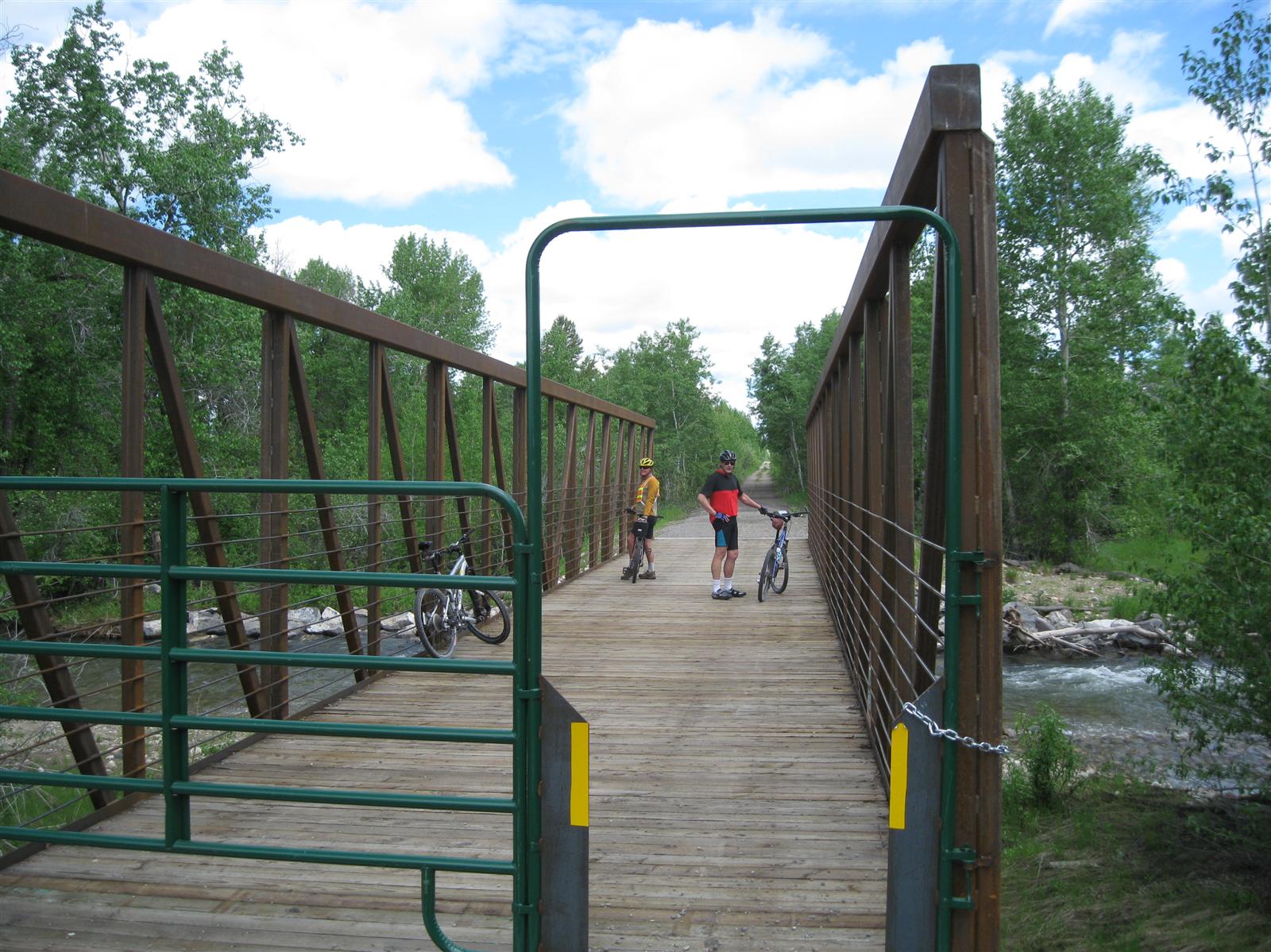
The views are better if you ride north-to-south, so you have better views of the Teton Range.
Teton Rail Trail (partial) at EveryTrail
Wednesday, June 23, 2010
Ski Lake and Beyond
A gorgeous day in Jackson Hole, so we went for a hike up to Ski Lake

and kept going on up above the lake into Horseshoe Bowl. There is a trail leading up out of the northwest corner of the bowl, so we followed that until we ran into too much snow at about 9500'. Great views looking north to the Grand, and every other direction for that matter.
 I couldn't find a name for the two small lakes in the foreground of this picture, they're at about 9000' just southwest of Phillips Pass.
Trip details at EveryTrail

and kept going on up above the lake into Horseshoe Bowl. There is a trail leading up out of the northwest corner of the bowl, so we followed that until we ran into too much snow at about 9500'. Great views looking north to the Grand, and every other direction for that matter.

Trip details at EveryTrail
Thursday, May 20, 2010
Pleasant Creek East, Capitol Reef
Capitol Reef might well be our favorite national park, and this might be our new favorite trail. Paul was still dealing with an injury, so he did a windshield tour while Pam, Jill and I did an out-and-back hike

The trail notes on the map say "lots of interesting side canyons to explore". We didn't explore them on this trip, but wow we plan to go back. Spending a couple of nights would be the way to check out all the side canyons.

The Capitol Reef Field Station (affiliated with Utah Valley University) is located in this canyon, what a beautiful setting.
More pictures and GPS log at EveryTrail.com
Wednesday, May 19, 2010
Frying Pan Trail, Capitol Reef NP
Paul was nursing a calf injury, so he played shuttle driver while Jill, Pam, and I hiked the Frying Pan trail from Grand Wash trailhead back up to the Fruita campground. It had been at least six or seven years since I'd been here, and had forgotten how gorgeous the views are. The trail goes up from the Grand Wash trailhead, with views of Cassidy Arch.
 The half-mile side trip to the arch is well worth it, particularly if you want to walk out on top of the arch like Pam and Jill here.
 The highest elevation on the trail is about 6600', with 360 degree views.

More pictures and GPS details at EveryTrail.com


More pictures and GPS details at EveryTrail.com
Tuesday, May 18, 2010
Upper Calf Creek Falls


We hiked about a mile downstream, staying up on the slickrock, before it was time to turn around. Doug P and his daughter Lexie hiked downstream on/in the creek, all the way to the top of Lower Calf Creek Falls, and then bushwhacked their way up to the highway. (And yes, it did rain!)
Subscribe to:
Comments (Atom)

